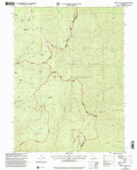
1997 Map of Trinity Mountain
USGS Topo · Published 2001About this map
The high ridges of the Six Rivers National Forest and Trinity National Forest dominate this landscape along the Humboldt and Trinity County line. Recorded in the late 1990s, the terrain is defined by a network of drainage systems including Tish Tang a Tang Creek and Linto Creek. The map documents numerous high-elevation flats and clearings such as Patterson Meadows, Mckay Meadows, and Lower Ferguson Meadows, which historically served as vital landmarks for those traversing these peaks.
Find a feature on this map
45 named features on this map. Tap any name to fly to it.
Don’t see what you’re looking for? This feature index may not catch every label — zoom into the map to look around manually.
Map Details
Editions of this 1997 Trinity Mountain Map
This is the sole edition of this map. No revisions or reprints were ever made.
Other maps of this area

1909 · Big Bar
USGS Topo · 1:96,000

1915 · Big Bar and Vicinity
USGS Topo · 1:250,000

1922 · China Flat
USGS Topo · 1:62,500

1925 · Hoopa
USGS Topo · 1:125,000

1948 · Weed
USGS Topo · 1:250,000

1950 · Weed
USGS Topo · 1:250,000

1951 · Ironside Mountain
USGS Topo · 1:62,500

1952 · Willow Creek
USGS Topo · 1:62,500

1952 · Hoopa
USGS Topo · 1:62,500

1955 · Salmon Mtn
USGS Topo · 1:62,500