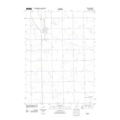
2012 Map of Tripp
USGS Topo · Published 2012About this map
Tripp serves as the primary hub of this eastern South Dakota landscape, where a dense cluster of burial sites reveals the deep immigrant and religious heritage of the prairie. Within a small radius south of town, researchers can locate Friedens Cem, Holy Rosary Cem, and Grace Hill Cem, each a vital record of early settler families. The surrounding rural townships are defined by a grid of section-line roads, such as N Main and 411th Ave, which cross the meandering paths of Emanuel Cr and Dawson Cr. Farther afield, the presence of Hoffnungstal Cem and the Saints Cyril and Methodius Cem along Vodnany Church Rd reflects the varied ethnic enclaves that established these farming communities. This survey provides a clear view of the agricultural drainage pattern, with Snatch Cr and S Br Lonetree Cr cutting through the high plains topography.
Find a feature on this map
36 named features on this map. Tap any name to fly to it.
Don’t see what you’re looking for? This feature index may not catch every label — zoom into the map to look around manually.
Map Details
Editions of this 2012 Tripp Map
This is the sole edition of this map. No revisions or reprints were ever made.
Other maps of this area

1898 · Olivet
USGS Topo · 1:125,000

1955 · Sioux Falls
USGS Topo · 1:250,000

1955 · Mitchell
USGS Topo · 1:250,000

1958 · Sioux Falls
USGS Topo · 1:250,000

1959 · Mitchell
USGS Topo · 1:250,000

1977 · Oak Hollow
USGS Topo · 1:24,000

1978 · Tripp SE
USGS Topo · 1:24,000

1978 · Oak Hollow
USGS Topo · 1:24,000
1978 · Haucks Lake
USGS Topo · 1:24,000
1978 · Kaylor
USGS Topo · 1:24,000