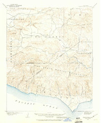
1900 Map of Triunfo Pass
USGS Topo · Published 1960About this map
Newbury Park and the small settlements of Triunfo and Cornell anchor this 1900 survey of the coastal mountains between Ventura and Los Angeles counties. The landscape is defined by the steep southern slopes of the Santa Monica Mountains, where dozens of narrow drainage systems like Arroyo Sequit and Trancas Canyon cut southward toward the Pacific Ocean. This early topographic study captures the region before the development of modern coastal highways, showing a network of mountain passes and valley trails that connected the interior Simi Valley and Potrero Valley to the coast. High peaks such as Sandstone Pk and Castro Pk provided the primary landmarks for surveyors marking the San Bernardino Base Line, while the western edge of the map shows the transition into the Guadalasca and Calleguas regions.
Find a feature on this map
50 named features on this map. Tap any name to fly to it.
Don’t see what you’re looking for? This feature index may not catch every label — zoom into the map to look around manually.
Map Details
Editions of this 1900 Triunfo Pass Map
2 editions found
Other maps of this area

1900 · Triunfo Pass
USGS Topo · 1:62,500

1900 · Piru
USGS Topo · 1:62,500

1903 · Santa Paula
USGS Topo · 1:62,500

1903 · Calabasas
USGS Topo · 1:62,500

1903 · Camulos
USGS Topo · 1:125,000

1903 · Santa Susana
USGS Topo · 1:62,500

1904 · Hueneme
USGS Topo · 1:62,500

1921 · Piru
USGS Topo · 1:62,500

1921 · Triunfo Pass
USGS Topo · 1:62,500

1929 · Dume Point
USGS Topo · 1:24,000