
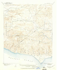
1900 Map of Triunfo Pass
USGS Topo · Published 1900About this map
The Santa Monica Mountains dominate this 1900 survey, presenting a complex landscape of ridges and deep canyons reaching the Pacific Ocean. This specific edition, developed by the Oil Map Association, features an unusual overlay of arbitrary township boundaries and section lines across lands that were not formally sectionalized by the General Land Office, including large land grants like El Conejo and Guadalasca.
Find a feature on this map
42 named features on this map. Tap any name to fly to it.
Don’t see what you’re looking for? This feature index may not catch every label — zoom into the map to look around manually.
Map Details
Editions of this 1900 Triunfo Pass Map
2 editions found
Other maps of this area

1900 · Piru
USGS Topo · 1:62,500

1903 · Santa Paula
USGS Topo · 1:62,500

1903 · Calabasas
USGS Topo · 1:62,500

1903 · Camulos
USGS Topo · 1:125,000

1903 · Santa Susana
USGS Topo · 1:62,500

1904 · Hueneme
USGS Topo · 1:62,500

1921 · Piru
USGS Topo · 1:62,500

1921 · Triunfo Pass
USGS Topo · 1:62,500

1929 · Dume Point
USGS Topo · 1:24,000

1929 · Vejor
USGS Topo · 1:24,000