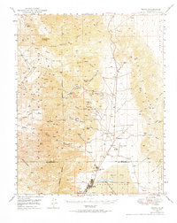
1949 Map of Trona
USGS Topo · Published 1984About this map
Industrial activity and desert topography define this high-altitude landscape near the junction of Inyo and San Bernardino Counties. The Trona Railway serves the chemical operations at Searles Lake, connecting the settlement of Trona and nearby Argus to the broader regional economy. The eastern portion of the sheet reveals the sharp elevation changes of the Slate Range and the Panamint Valley, where the Naval Ordnance Test Station Reservation marks a transition into military-controlled territory. Scattered throughout the mountains are numerous small-scale mining operations like the Orendo Mine and Veeta Mine, alongside vital water sources such as Indian Joe Spring and Bainter Spring. This 1940s landscape shows the critical infrastructure required for desert survival and industry, from the isolated Valley Wells to the remote Trona Airport.
Find a feature on this map
49 named features on this map. Tap any name to fly to it.
Don’t see what you’re looking for? This feature index may not catch every label — zoom into the map to look around manually.
Map Details
Editions of this 1949 Trona Map
4 editions found
Other maps of this area

1908 · Ballarat
USGS Topo · 1:250,000

1913 · Ballarat
USGS Topo · 1:250,000

1915 · Searles Lake
USGS Topo · 1:250,000

1947 · Trona
USGS Topo · 1:250,000

1948 · Trona
USGS Topo · 1:250,000

1948 · Death Valley
USGS Topo · 1:250,000

1949 · Trona
USGS Topo · 1:62,500

1949 · Searles Lake
USGS Topo · 1:62,500

1950 · Searles Lake
USGS Topo · 1:62,500

1950 · Trona
USGS Topo · 1:62,500