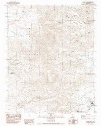
1983 Map of Trona West
USGS Topo · Published 1983About this map
Argus Range terrain dominates this survey of the California desert, where industrial mineral extraction and military operations meet at the edge of the Searles Lake salt pan. The settlements of Trona and Argus are established at the base of the mountains, supported by a network of resource sites including a Gravel Pit and several Prospect locations. The map illustrates a complex relationship between the natural landscape and human utility, with the massive Naval Weapons Center China Lake boundary consuming much of the western terrain.
Find a feature on this map
40 named features on this map. Tap any name to fly to it.
Don’t see what you’re looking for? This feature index may not catch every label — zoom into the map to look around manually.
Map Details
Editions of this 1983 Trona West Map
This is the sole edition of this map. No revisions or reprints were ever made.
Other maps of this area

1915 · Searles Lake
USGS Topo · 1:250,000

1947 · Trona
USGS Topo · 1:250,000

1948 · Trona
USGS Topo · 1:250,000

1949 · Trona
USGS Topo · 1:62,500

1949 · Searles Lake
USGS Topo · 1:62,500

1950 · Searles Lake
USGS Topo · 1:62,500

1950 · Trona
USGS Topo · 1:62,500

1953 · Mountain Springs Canyon
USGS Topo · 1:62,500

1953 · Ridgecrest
USGS Topo · 1:62,500

1953 · Trona
USGS Topo · 1:250,000