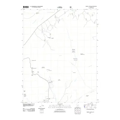
2011 Map of Tropic Canyon
USGS Topo · Published 2011About this map
Tropic sits at the southern edge of this study, serving as a gateway to a landscape defined by dramatic geological formations and complex drainage systems. The town is anchored near the Paria River and the local Tropic Cemetery, with State Rte 22 providing the primary corridor through the high-elevation terrain. This 2011 survey documents the intricate network of canyons and points that characterize the region, including the descriptive Sinking Ship, Fairyland Canyon, and the prominent ridge known as The Backbone.
Find a feature on this map
31 named features on this map. Tap any name to fly to it.
Don’t see what you’re looking for? This feature index may not catch every label — zoom into the map to look around manually.
Map Details
Editions of this 2011 Tropic Canyon Map
This is the sole edition of this map. No revisions or reprints were ever made.
Other maps of this area

1886 · Kanab
USGS Topo · 1:250,000

1886 · Escalante
USGS Topo · 1:250,000

1953 · Cedar City
USGS Topo · 1:250,000

1956 · Escalante
USGS Topo · 1:250,000

1958 · Cedar City
USGS Topo · 1:250,000

1960 · Escalante
USGS Topo · 1:250,000

1962 · Cedar City
USGS Topo · 1:250,000

1964 · Henrieville
USGS Topo · 1:24,000
1964 · Sweetwater Creek
USGS Topo · 1:24,000
1964 · Pine Lake
USGS Topo · 1:24,000