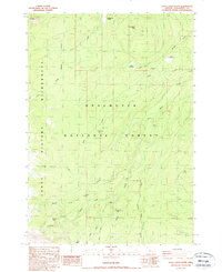
1988 Map of Trout Creek Butte
USGS Topo · Published 1988About this map
Trout Creek Butte and the volcanic terrain of Millican Crater define this high-altitude landscape within the Deschutes National Forest. Recorded through field checks in the late 1950s and mid-1980s, the map reveals a complex drainage network feeding into the Squaw Creek system. The western portion of the quadrangle is occupied by the protected Three Sisters Wilderness, where the terrain rises toward the high peaks of the Cascade Range. Water is a defining element of this forest environment, from the high-elevation Demaris Lake and Squaw Creek Falls to the sprawling Trout Creek Swamp in the north. The presence of numerous named water sources like Pole Creek Spring and Spruce Spring, alongside features like the Twin Meadows, indicates the vital importance of seasonal and permanent water for both wildlife and forest management in this central Oregon region.
Find a feature on this map
26 named features on this map. Tap any name to fly to it.
Don’t see what you’re looking for? This feature index may not catch every label — zoom into the map to look around manually.
Map Details
Editions of this 1988 Trout Creek Butte Map
2 editions found
Other maps of this area

1929 · Three Sisters
USGS Topo · 1:125,000

1932 · Three Sisters
USGS Topo · 1:125,000

1955 · Bend
USGS Topo · 1:250,000

1957 · Bend
USGS Topo · 1:250,000

1958 · Bend
USGS Topo · 1:250,000

1959 · Broken Top
USGS Topo · 1:62,500
1959 · Three Sisters
USGS Topo · 1:62,500

1959 · Three Fingered Jack
USGS Topo · 1:62,500

1959 · Sisters
USGS Topo · 1:62,500
1980 · Bend
USGS Topo · 1:100,000