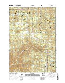
2014 Map of Trout Meadows
USGS Topo · Published 2014About this map
The N Fork John Day River carves through the central portion of this 2014 survey, marking a rugged boundary where the Whitman National Forest and Umatilla National Forest converge. This high-elevation landscape is defined by its series of upland clearings and water sources, including the eponymous Trout Meadows and the nearby Trout Meadows Butte. The intersection of Union Co and Grant Co is documented here, showing the intricate geopolitical lines that bisect these wilderness areas. A complex network of timber and access roads, such as Natl Forest Develop Road 52 Rd, provides the primary infrastructure for this remote region. From the southern expanse of Happy Prairie to the northern heights of White Pine Knob, the map details a terrain of gulches and creeks, including Wagner Gulch and Meadow Cr, that have long served as vital landmarks for forestry and local conservation efforts.
Find a feature on this map
38 named features on this map. Tap any name to fly to it.
Don’t see what you’re looking for? This feature index may not catch every label — zoom into the map to look around manually.
Map Details
Editions of this 2014 Trout Meadows Map
This is the sole edition of this map. No revisions or reprints were ever made.
Other maps of this area

1901 · Sumpter
USGS Topo · 1:125,000

1951 · Desolation Butte
USGS Topo · 1:62,500

1953 · Pendleton
USGS Topo · 1:250,000

1955 · Canyon City
USGS Topo · 1:250,000

1956 · Pendleton
USGS Topo · 1:250,000

1959 · Canyon City
USGS Topo · 1:250,000

1965 · Limber Jim Creek
USGS Topo · 1:24,000

1965 · Fly Valley
USGS Topo · 1:24,000

1967 · Tower Mtn
USGS Topo · 1:24,000

1972 · Trout Meadows
USGS Topo · 1:24,000