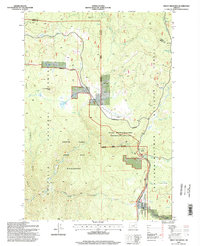
1995 Map of Trout Meadows
USGS Topo · Published 1998About this map
Klopp Placer Mine and the Thornburg Placer Mine stand as evidence of the mineral extraction history along the North Fork John Day River in this part of eastern Oregon. This 1995 survey highlights a landscape managed by overlapping jurisdictions of the Umatilla National Forest and the Wallowa-Whitman National Forest. The complex drainage network is defined by high-elevation terrain like White Pine Knob and Trout Meadows Butte, where numerous Spring and Springs labels feed into Blue Meadow Creek and Davis Creek. The presence of numerous Drill Holes scattered across the northern sections suggests ongoing geological exploration or resource assessment during the late 20th century. Remote access is facilitated by the Packsaddle Trail and various unpaved roads, connecting isolated locations like Happy Prairie and the meadowlands of Cabell Meadow.
Find a feature on this map
31 named features on this map. Tap any name to fly to it.
Don’t see what you’re looking for? This feature index may not catch every label — zoom into the map to look around manually.
Map Details
Editions of this 1995 Trout Meadows Map
This is the sole edition of this map. No revisions or reprints were ever made.
Other maps of this area

1901 · Sumpter
USGS Topo · 1:125,000

1951 · Desolation Butte
USGS Topo · 1:62,500

1953 · Pendleton
USGS Topo · 1:250,000

1955 · Canyon City
USGS Topo · 1:250,000

1956 · Pendleton
USGS Topo · 1:250,000

1959 · Canyon City
USGS Topo · 1:250,000

1965 · Limber Jim Creek
USGS Topo · 1:24,000

1965 · Fly Valley
USGS Topo · 1:24,000

1967 · Tower Mtn
USGS Topo · 1:24,000

1972 · Trout Meadows
USGS Topo · 1:24,000