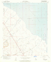
1956 Map of Truckhaven
USGS Topo · Published 1957About this map
The Salton Sea dominates the eastern half of this mid-century desert landscape, with a shoreline recorded at an elevation of 235 feet below sea level in May 1956. This era reveals a stark intersection of tribal lands, military activity, and desert outpost life. To the north, the Torres Martinez Indian Reservation borders the basin, while the shoreline is occupied by the Salton Sea Test Base and its specialized Salton Sea Test Base B-1 installation. The small settlement of Truckhaven serves as a primary reference point along the Anza route, situated amidst a complex drainage system of desert washes including Palm Wash, Verde Wash, and Coral Wash. Further south, the landscape transitions into the topographic features of Clay Point and the named locality of Squeaky Springs near Arroyo Salada.
Find a feature on this map
24 named features on this map. Tap any name to fly to it.
Don’t see what you’re looking for? This feature index may not catch every label — zoom into the map to look around manually.
Map Details
Editions of this 1956 Truckhaven Map
3 editions found
Other maps of this area

1904 · Indio
USGS Topo · 1:125,000

1931 · Vallecito
USGS Topo · 1:125,000

1940 · Kane Spring
USGS Topo · 1:62,500

1940 · Durmid
USGS Topo · 1:62,500

1942 · Barrel Spring
USGS Topo · 1:62,500

1942 · Agua Dulce
USGS Topo · 1:62,500

1943 · Vallecito
USGS Topo · 1:125,000

1944 · Agua Dulce
USGS Topo · 1:62,500

1944 · Durmid
USGS Topo · 1:62,500

1944 · Kane Spring
USGS Topo · 1:62,500