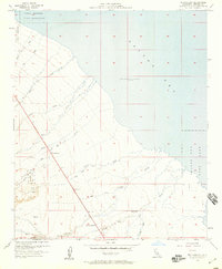
1956 Map of Truckhaven
USGS Topo · Published 1959About this map
The arid shoreline of the Salton Sea dominates this mid-century survey of Imperial County, revealing a landscape defined by seasonal desert drainages and specialized government activity. At the time of this 1956 study, the sea level was recorded at 235 feet below sea level, creating a vast alluvial expanse where numerous washes like Palm Wash, Arroyo Salada, and Tule Wash fan out toward the water. The small settlement of Truckhaven serves as a primary reference point along the highway, while the presence of the Salton Sea Test Base suggests the area's strategic importance during the Cold War era.
Find a feature on this map
25 named features on this map. Tap any name to fly to it.
Don’t see what you’re looking for? This feature index may not catch every label — zoom into the map to look around manually.
Map Details
Editions of this 1956 Truckhaven Map
3 editions found
Other maps of this area

1904 · Indio
USGS Topo · 1:125,000

1931 · Vallecito
USGS Topo · 1:125,000

1940 · Kane Spring
USGS Topo · 1:62,500

1940 · Durmid
USGS Topo · 1:62,500

1942 · Barrel Spring
USGS Topo · 1:62,500

1942 · Agua Dulce
USGS Topo · 1:62,500

1943 · Vallecito
USGS Topo · 1:125,000

1944 · Agua Dulce
USGS Topo · 1:62,500

1944 · Durmid
USGS Topo · 1:62,500

1944 · Kane Spring
USGS Topo · 1:62,500