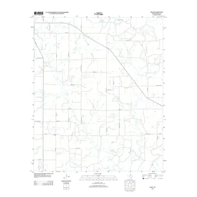
2012 Map of True
USGS Topo · Published 2012About this map
True stands at the center of this rural Young County landscape, situated at the junction of True Rd and Taack Rd. The area is defined by a dense network of watercourses, with Salt Cr winding through the south and central regions, joined by tributaries such as Dry Cr and Big Skid Cr. To the northeast, the Benson Oil Field highlights the local energy industry, while the northern terrain is crossed by Olney Rd and Red Haw Cr. The survey captures a region where agriculture and resource extraction meet, evidenced by the many local access routes like Rothell Pringle Rd and McClatchey Rd that connect dispersed farmsteads. The confluence of Little Salt Cr and other branches near White Water illustrates the intricate drainage patterns essential to this Texas prairie environment.
Find a feature on this map
35 named features on this map. Tap any name to fly to it.
Don’t see what you’re looking for? This feature index may not catch every label — zoom into the map to look around manually.
Map Details
Editions of this 2012 True Map
This is the sole edition of this map. No revisions or reprints were ever made.
Other maps of this area

1927 · Graham
USGS Topo · 1:62,500

1954 · Wichita Falls
USGS Topo · 1:250,000

1958 · Wichita Falls
USGS Topo · 1:250,000

1964 · Newcastle
USGS Topo · 1:24,000

1964 · Bobcat Bluff
USGS Topo · 1:24,000

1964 · True
USGS Topo · 1:24,000

1964 · Loving
USGS Topo · 1:24,000

1964 · Lake Eddleman
USGS Topo · 1:24,000
1964 · Prickly Pear Branch
USGS Topo · 1:24,000
1964 · Lake Olney
USGS Topo · 1:24,000