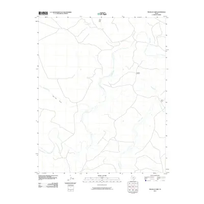
2010 Map of Trujillo Camp
USGS Topo · Published 2010About this map
The Canadian River meanders across this high plains terrain in Oldham County, carving a distinct hydrological path through the landscape near the Texas-New Mexico border. This 2010 survey highlights a region defined by its ranching heritage and water management, where named landmarks like Boydstun Windmill signify the vital infrastructure needed to support life in the arid Panhandle. The network of drainage includes Nara Visa Arroyo and Agua de Piedra Creek, which feed into the primary river system. Near the eastern edge, the remote settlement of Trujillo Camp sits along the winding course of Trujillo Creek. To the north, the terrain grows more complex as Horse Creek approaches the steep descents of Chisum Canyon, illustrating the transition from open grazing land to the deeply eroded breaks of the Canadian River valley.
Find a feature on this map
8 named features on this map. Tap any name to fly to it.
Don’t see what you’re looking for? This feature index may not catch every label — zoom into the map to look around manually.
Map Details
Editions of this 2010 Trujillo Camp Map
This is the sole edition of this map. No revisions or reprints were ever made.
Other maps of this area

1954 · Tucumcari
USGS Topo · 1:250,000

1958 · Tucumcari
USGS Topo · 1:250,000

1966 · Signal Spring
USGS Topo · 1:24,000

1966 · Signal Spring SE
USGS Topo · 1:24,000

1966 · Vat Camp
USGS Topo · 1:24,000

1966 · Trujillo Camp
USGS Topo · 1:24,000

1968 · Sanchez Springs
USGS Topo · 1:24,000
1968 · Martin Draw
USGS Topo · 1:24,000

1971 · Romero SE
USGS Topo · 1:24,000

1971 · Nara Visa
USGS Topo · 1:24,000