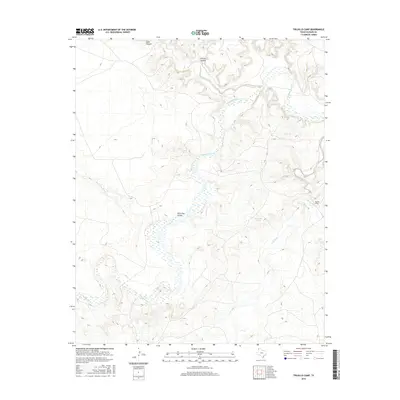
2016 Map of Trujillo Camp
USGS Topo · Published 2016About this map
Trujillo Camp serves as a lone point of habitation within this corner of Oldham County, where the sprawling drainage of the Canadian River dictates the landscape. The river, shown with its braided channels and intermittent flow patterns, is fed by several significant watercourses including Trujillo Cr and the Nara Visa Arroyo. The northern portion of the quadrangle is defined by steep elevation changes, particularly around Sidle Canyon and Chisum Canyon, which cut through the High Plains towards Horse Creek. This survey records a remote ranching and natural area, highlighting specific water sources like Blue Goose Springs and Agua de Piedra Cr that have likely served as vital landmarks for generations in this arid Texas Panhandle environment.
Find a feature on this map
10 named features on this map. Tap any name to fly to it.
Don’t see what you’re looking for? This feature index may not catch every label — zoom into the map to look around manually.
Map Details
Editions of this 2016 Trujillo Camp Map
This is the sole edition of this map. No revisions or reprints were ever made.
Other maps of this area

1954 · Tucumcari
USGS Topo · 1:250,000

1958 · Tucumcari
USGS Topo · 1:250,000

1966 · Signal Spring
USGS Topo · 1:24,000

1966 · Signal Spring SE
USGS Topo · 1:24,000

1966 · Vat Camp
USGS Topo · 1:24,000

1966 · Trujillo Camp
USGS Topo · 1:24,000

1968 · Sanchez Springs
USGS Topo · 1:24,000
1968 · Martin Draw
USGS Topo · 1:24,000

1971 · Romero SE
USGS Topo · 1:24,000

1971 · Nara Visa
USGS Topo · 1:24,000