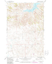
1971 Map of Trumbo Ranch
USGS Topo · Published 1987About this map
Charles M Russell National Wildlife Refuge dominates the northern reaches of this Garfield County landscape, preserving the wild character of the Missouri River breaks. The 1971 topography, with 1982 revisions, illustrates the complex drainage system feeding into the southern edge of Fort Peck Lake. Long, winding waterways like Snow Creek, Hell Creek, and Cottonwood Creek have carved deep incisions through the terrain, illustrating the dramatic erosion characteristic of this region. The presence of Trumbo Ranch near the center of the map highlights the enduring legacy of Montana's ranching heritage in an area otherwise defined by protected federal lands and the prominent silhouette of Brownie Butte. These named coulees and springs provide a detailed record of water sources that were essential for early settlers and livestock in the semi-arid northern plains.
Find a feature on this map
11 named features on this map. Tap any name to fly to it.
Don’t see what you’re looking for? This feature index may not catch every label — zoom into the map to look around manually.
Map Details
Editions of this 1971 Trumbo Ranch Map
2 editions found
Other maps of this area

1954 · Jordan
USGS Topo · 1:250,000

1956 · Jordan
USGS Topo · 1:250,000

1958 · Jordan
USGS Topo · 1:250,000

1958 · Maloney Hill
USGS Topo · 1:62,500

1964 · Jordan
USGS Topo · 1:250,000

1964 · Jordan NW
USGS Topo · 1:24,000

1971 · Hell Hollow
USGS Topo · 1:24,000

1971 · Trumbo Ranch
USGS Topo · 1:24,000

1971 · Wagon Coulee
USGS Topo · 1:24,000

1971 · Harper Camp
USGS Topo · 1:24,000