
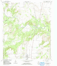
1966 Map of Truscott North
USGS Topo · Published 1968About this map
Truscott serves as the primary hub of this 1960s West Texas landscape, positioned just south of a complex drainage network feeding into the North Wichita River. The topography is defined by the sharp transition between the upland plains and the dissected breaks carved by Salt Flat Creek and Bluff Creek. The Atchison Topeka and Santa Fe railroad cuts a straight north-south line across these varied elevations, bridging the river at a point marked by a Gaging Sta and nearby Gravel Pits.
Find a feature on this map
16 named features on this map. Tap any name to fly to it.
Don’t see what you’re looking for? This feature index may not catch every label — zoom into the map to look around manually.
Map Details
Editions of this 1966 Truscott North Map
2 editions found
Other maps of this area

1954 · Wichita Falls
USGS Topo · 1:250,000

1958 · Wichita Falls
USGS Topo · 1:250,000

1966 · Truscott South
USGS Topo · 1:24,000

1966 · Halsell Ranch
USGS Topo · 1:24,000

1966 · Gilliland
USGS Topo · 1:24,000

1966 · Big Four Ranch
USGS Topo · 1:24,000

1966 · Crowell
USGS Topo · 1:24,000

1966 · Maverick Flat
USGS Topo · 1:24,000
1968 · Boiling Spring
USGS Topo · 1:24,000
1968 · Foard City
USGS Topo · 1:24,000