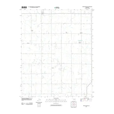
2010 Map of Tryon South
USGS Topo · Published 2010About this map
Valley Queen Cemetery and Rock Spring Cemetery anchor the rural landscape of Lincoln County in this 21st-century survey of the Oklahoma plains. The small community of Tryon is situated at the northern edge of the sheet, where residential streets meet the systematic grid of section roads like e0800 RD. To the west, the settlement of Anderson is surrounded by a patchwork of small ponds and drainage creeks that define the local topography. This map documents a region where agricultural land use is punctuated by modern infrastructure, notably Melton Airport and several localized water management features such as the Oknoname 08116 Reservoir and its associated Oknoname 08116 Dam. The road network is heavily developed on a mile-by-mile basis, featuring thoroughfares like Post RD and n3390 RD that facilitate movement between the scattered farmsteads and small towns of central Oklahoma.
Find a feature on this map
25 named features on this map. Tap any name to fly to it.
Don’t see what you’re looking for? This feature index may not catch every label — zoom into the map to look around manually.
Map Details
Editions of this 2010 Tryon South Map
This is the sole edition of this map. No revisions or reprints were ever made.
Other maps of this area

1905 · Chandler
USGS Topo · 1:62,500

1907 · Chandler
USGS Topo · 1:62,500

1908 · Agra
USGS Topo · 1:62,500

1909 · Luther
USGS Topo · 1:62,500

1909 · Perkins
USGS Topo · 1:62,500

1954 · Oklahoma City
USGS Topo · 1:250,000

1957 · Oklahoma City
USGS Topo · 1:250,000

1963 · Oklahoma City
USGS Topo · 1:250,000
1966 · Wellston
USGS Topo · 1:24,000
1974 · Chandler
USGS Topo · 1:24,000