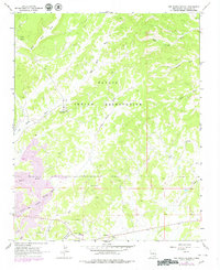
1963 Map of Tse Bonita School
USGS Topo · Published 1980About this map
The Navajo Indian Reservation landscape documented in this 1960s survey is defined by the extraction of natural resources and a complex network of seasonal drainages. Industrial activity is centered around the Window Rock Coal Mine and a large Strip Mine in the southwest, where a prominent Pipeline and a Gravel Pit further indicate the era's focus on local mineral and energy production.
Find a feature on this map
21 named features on this map. Tap any name to fly to it.
Don’t see what you’re looking for? This feature index may not catch every label — zoom into the map to look around manually.
Map Details
Editions of this 1963 Tse Bonita School Map
2 editions found
Other maps of this area

1886 · Wingate
USGS Topo · 1:250,000

1886 · Fort Defiance
USGS Topo · 1:250,000

1892 · Fort Defiance
USGS Topo · 1:250,000

1892 · Wingate
USGS Topo · 1:250,000

1954 · Gallup
USGS Topo · 1:250,000

1955 · Zith-Tusayan Butte 4 NE
USGS Topo · 1:24,000

1955 · Zith-Tusayan Butte 1 SE
USGS Topo · 1:24,000

1955 · Tohatchi
USGS Topo · 1:62,500
1955 · Buell Park
USGS Topo · 1:62,500

1958 · Gallup
USGS Topo · 1:250,000