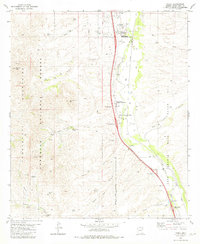
1981 Map of Tubac
USGS Topo · Published 1981About this map
The Santa Cruz River valley serves as a central corridor for settlement and transit in this southern Arizona landscape. Anchored by the historic Tubac area and the Tumacacori National Monument, the map documents a region where Spanish colonial history meets 20th-century ranching and infrastructure. The Southern Pacific railroad parallels the river, connecting smaller locales like Carmen and Calabasas. Away from the valley floor, the terrain rises into the Tumacacori Mountains and the Coronado National Forest, where a network of canyons such as Aliso Canyon and Rock Corral Canyon define the watershed. Notable for local history researchers are the numerous named wells and ranch sites, including the Kenyon Ranch and Rock Corral Ranch, as well as unique landmarks like the CCC Dam and the Camp Loco ruins tucked into the western ridges.
Find a feature on this map
54 named features on this map. Tap any name to fly to it.
Don’t see what you’re looking for? This feature index may not catch every label — zoom into the map to look around manually.
Map Details
Editions of this 1981 Tubac Map
3 editions found
Other maps of this area

1904 · Patagonia
USGS Topo · 1:125,000

1905 · Patagonia
USGS Topo · 1:125,000

1905 · Nogales
USGS Topo · 1:125,000

1920 · Arivaca
USGS Topo · 1:125,000

1921 · Old Glory
USGS Topo · 1:125,000

1922 · Agus Caliente
USGS Topo · 1:62,500

1933 · Calabasas
USGS Topo · 1:62,500

1939 · Tubac
USGS Topo · 1:62,500

1942 · Ruby
USGS Topo · 1:62,500

1943 · Old Glory
USGS Topo · 1:125,000