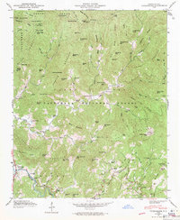
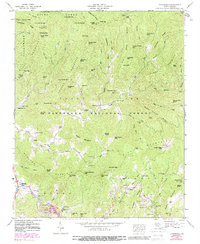
1946 Map of Tuckasegee
USGS Topo · Published 1971About this map
The Tuckasegee River carves through the southern landscape of this mid-century Jackson County survey, where the valley floor supports the community of Tuckasegee and the neighboring settlements of Cowarts and Argura. High-elevation landmarks like Brasstown Knob and Sassafras Knob rise within the Nantahala National Forest, illustrating the deep verticality of the Blue Ridge terrain before major development. This 1946 field examination captures a network of rural institutions, including the Caney Fork Sch and the Oak Hill Sch, alongside numerous family burial grounds such as Stephenson Cem and Brasstown Cem. Significant cultural sites like Judaculla Rock are documented alongside a web of creeks—including Caney Fork and Sugar Creek—that dictated the placement of early mountain homesteads and churches like Catherine Chapel and Balsam Grove Ch.
Find a feature on this map
97 named features on this map. Tap any name to fly to it.
Don’t see what you’re looking for? This feature index may not catch every label — zoom into the map to look around manually.
Map Details
Editions of this 1946 Tuckasegee Map
5 editions found
Other maps of this area

1891 · Cowee
USGS Topo · 1:125,000

1897 · Cowee
USGS Topo · 1:125,000

1905 · Pisgah
USGS Topo · 1:125,000

1906 · Pisgah
USGS Topo · 1:125,000

1907 · Cowee
USGS Topo · 1:125,000

1935 · Waynesville
USGS Topo · 1:24,000

1935 · Sam Knob
USGS Topo · 1:24,000

1935 · Tuckaseigee
USGS Topo · 1:24,000

1935 · Hazelwood
USGS Topo · 1:24,000

1935 · Lake Toxaway
USGS Topo · 1:24,000