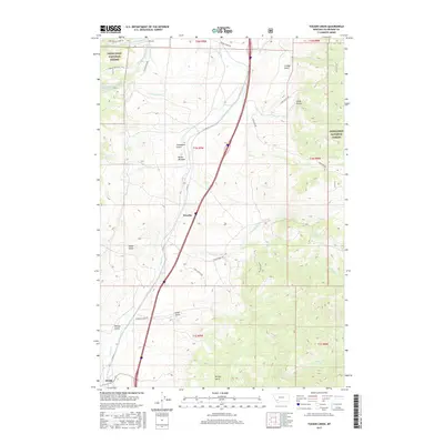
2017 Map of Tucker Creek
USGS Topo · Published 2017About this map
Woodin and the settlement of Divide anchor this topographic view of the Silver Bow County landscape, where the continental divide transitions into high mountain drainages and steep gulches. The terrain is defined by a network of seasonal and perennial waters, including the headwaters of Divide Cr and the eastern flow of Tucker Cr. Within the bounds of the Deerlodge National Forest, numerous named gulches like Freezeout Gulch, Climax Gulch, and Selway Gulch suggest a history of prospecting or local naming conventions common to Montana's mining districts. High-elevation features like Butler Meadow and the S Fork Reservoir sit above the valley floor, while roads such as St Hwy 91 and the oddly named Humbug Acres Rd trace the path of modern travel and habitation through this high-country corridor.
Find a feature on this map
37 named features on this map. Tap any name to fly to it.
Don’t see what you’re looking for? This feature index may not catch every label — zoom into the map to look around manually.
Map Details
Editions of this 2017 Tucker Creek Map
This is the sole edition of this map. No revisions or reprints were ever made.
Other maps of this area

1893 · Dillon
USGS Topo · 1:250,000

1955 · Dillon
USGS Topo · 1:250,000

1957 · Dillon
USGS Topo · 1:250,000

1958 · Dillon
USGS Topo · 1:250,000

1958 · Vipond Park
USGS Topo · 1:62,500

1961 · Melrose
USGS Topo · 1:24,000
1961 · Burnt Mountain
USGS Topo · 1:24,000

1961 · Wickiup Creek
USGS Topo · 1:24,000

1961 · Butte South
USGS Topo · 1:62,500

1961 · Dewey
USGS Topo · 1:24,000