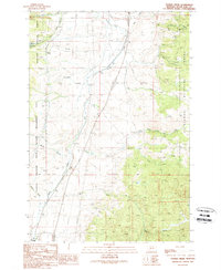
1989 Map of Tucker Creek
USGS Topo · Published 1989About this map
Deerlodge National Forest and the Fleecer Mountain State Wildlife Management Area dominate this section of Silver Bow County, where the landscape is defined by the headwaters of the Divide drainage system. The terrain is deeply incised by numerous gulches, including the colorfully named Crazy Swede Creek, Freezeout Gulch, and Climax Gulch. Evidence of the region's extractive history is scattered throughout the slopes, with numerous Prospect markings, Mine Shafts, and a Quarry indicating widespread mineral exploration in the late 20th century. Notable local landmarks include the Fleecer FS Sta and the South Fork Res, while the Highland Road provides the primary passage through the high country. The map captures a moment of balance between protected wildlife habitat and active mining prospecting across the Montana backcountry.
Find a feature on this map
31 named features on this map. Tap any name to fly to it.
Don’t see what you’re looking for? This feature index may not catch every label — zoom into the map to look around manually.
Map Details
Editions of this 1989 Tucker Creek Map
This is the sole edition of this map. No revisions or reprints were ever made.
Other maps of this area

1893 · Dillon
USGS Topo · 1:250,000

1955 · Dillon
USGS Topo · 1:250,000

1957 · Dillon
USGS Topo · 1:250,000

1958 · Dillon
USGS Topo · 1:250,000

1958 · Vipond Park
USGS Topo · 1:62,500

1961 · Melrose
USGS Topo · 1:24,000
1961 · Burnt Mountain
USGS Topo · 1:24,000

1961 · Wickiup Creek
USGS Topo · 1:24,000

1961 · Butte South
USGS Topo · 1:62,500

1961 · Dewey
USGS Topo · 1:24,000