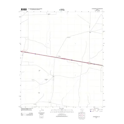
2012 Map of Tucker Hill
USGS Topo · Published 2012About this map
Tucker Hill and Hayter Hill dominate this arid West Texas landscape in Pecos County, where the necessity of water management is the primary marker of human presence. This 2012 survey reveals a sparse network of ranching infrastructure defined by family and location-named landmarks. The map is notably dotted with several named windmills, such as Metzger Windmill, Riggs Windmill, and Estate Windmill, each serving as a vital node in the local cattle economy. Transport and movement across this open expanse are channeled through the corridor of Ih 10, which cuts horizontally across the sheet. Surface water is intermittent at best, represented by the ephemeral channels of Schoolhouse Draw and Hackberry Draw. The layout of local roads like Mendel Rd and Hovey Rd reflects the large-scale land divisions and remote ranch access points typical of the region.
Find a feature on this map
14 named features on this map. Tap any name to fly to it.
Don’t see what you’re looking for? This feature index may not catch every label — zoom into the map to look around manually.
Map Details
Editions of this 2012 Tucker Hill Map
This is the sole edition of this map. No revisions or reprints were ever made.
Other maps of this area

1929 · Hovey
USGS Topo · 1:125,000

1931 · Barstow
USGS Topo · 1:125,000

1954 · Pecos
USGS Topo · 1:250,000

1954 · Fort Stockton
USGS Topo · 1:250,000

1957 · Pecos
USGS Topo · 1:250,000

1958 · Fort Stockton
USGS Topo · 1:250,000

1970 · Belding SW
USGS Topo · 1:24,000

1970 · Tucker Hill
USGS Topo · 1:24,000

1970 · Deep Well Ranch
USGS Topo · 1:24,000
1970 · Barstow 3 SW
USGS Topo · 1:24,000