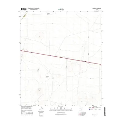
2016 Map of Tucker Hill
USGS Topo · Published 2016About this map
Tucker Hill and Hayter Hill rise as prominent topographical landmarks in this high-desert region of West Texas during the mid-2010s. The landscape is defined by its drainage patterns and transportation infrastructure, particularly the intermittent watercourses of Hackberry Draw and Schoolhouse Draw that cut through the arid terrain. The proximity of the Reeves and Pecos County line highlights the administrative boundaries that intersect this sparse area. Transportation is anchored by the presence of I10 Svc Rd, reflecting the modern corridor of Interstate 10 as it traverses the expansive plains. Local travel is facilitated by a network of rural routes including Mendel Rd, Hovey Rd, and Tinkler Rd, which serve the occasional ranch holdings and utility access points throughout the quadrangle.
Find a feature on this map
9 named features on this map. Tap any name to fly to it.
Don’t see what you’re looking for? This feature index may not catch every label — zoom into the map to look around manually.
Map Details
Editions of this 2016 Tucker Hill Map
This is the sole edition of this map. No revisions or reprints were ever made.
Other maps of this area

1929 · Hovey
USGS Topo · 1:125,000

1931 · Barstow
USGS Topo · 1:125,000

1954 · Pecos
USGS Topo · 1:250,000

1954 · Fort Stockton
USGS Topo · 1:250,000

1957 · Pecos
USGS Topo · 1:250,000

1958 · Fort Stockton
USGS Topo · 1:250,000

1970 · Belding SW
USGS Topo · 1:24,000

1970 · Tucker Hill
USGS Topo · 1:24,000

1970 · Deep Well Ranch
USGS Topo · 1:24,000
1970 · Barstow 3 SW
USGS Topo · 1:24,000