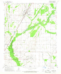
1965 Map of Tuckerman
USGS Topo · Published 1966About this map
The Missouri Pacific railroad corridor anchors the landscape of central Jackson County, connecting the agricultural hubs of Tuckerman and Campbell Station. In the mid-1960s, this region was defined by its intricate drainage network, where Village Creek and various artificial channels like Swan Pond Ditch managed the wetlands of the Mississippi Alluvial Plain. The map reveals a dense social fabric of rural life through its numerous burial grounds, including Gracelawn Cem, Prysock Cem, and Parrott Cem, often situated near small congregations such as New Hope Ch. To the south, the expansion of Newport is evident at the Newport Municipal Airport and the residential pocket of Airport Village. This survey captures the transition from traditional river-and-rail dependency toward modern aviation and road infrastructure, while the landscape remains dotted with family-named landmarks like Guthrie Lake and Parrott Lake.
Find a feature on this map
42 named features on this map. Tap any name to fly to it.
Don’t see what you’re looking for? This feature index may not catch every label — zoom into the map to look around manually.
Map Details
Editions of this 1965 Tuckerman Map
2 editions found
Other maps of this area

1932 · Strawberry
USGS Topo · 1:62,500

1935 · Alicia
USGS Topo · 1:62,500

1935 · Strawberry
USGS Topo · 1:62,500

1935 · Newport
USGS Topo · 1:62,500

1935 · Tuckerman
USGS Topo · 1:62,500

1941 · Strawberry
USGS Topo · 1:62,500

1953 · Memphis
USGS Topo · 1:250,000

1955 · Cord
USGS Topo · 1:24,000

1956 · Memphis
USGS Topo · 1:250,000

1962 · Jacksonport
USGS Topo · 1:24,000