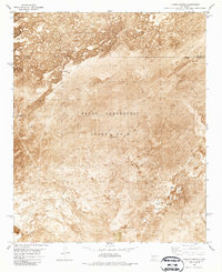
1982 Map of Tucson Spring
USGS Topo · Published 1987About this map
The Pedro Armendaris Grant No 33 dominates this landscape in Sierra County, illustrating the enduring legacy of Spanish and Mexican land grants in the American Southwest. The terrain is defined by stark volcanic features, labeled simply as Lava, which create a complex environment for the few established outposts like Casa Grande Ranch. Water is the critical factor for survival and navigation in this arid region, marked by a network of isolated points including Tucson Spring, Mc Kinney Well, and the Flowing Well. Near the southwestern corner, Red Lake and the Elephant Butte Station provide further evidence of the sparse but vital human infrastructure in this high-desert setting. The transition between Socorro and Sierra counties is noted by an indefinite boundary, reflecting the open and challenging nature of the local geography.
Find a feature on this map
15 named features on this map. Tap any name to fly to it.
Don’t see what you’re looking for? This feature index may not catch every label — zoom into the map to look around manually.
Map Details
Editions of this 1982 Tucson Spring Map
2 editions found
Other maps of this area

1916 · Salinas Peak
USGS Topo · 1:125,000

1948 · Val Verde
USGS Topo · 1:62,500

1948 · Malpais Well
USGS Topo · 1:62,500

1954 · Tularosa
USGS Topo · 1:250,000

1958 · Tularosa
USGS Topo · 1:250,000

1961 · Paraje Well
USGS Topo · 1:24,000

1961 · Crocker
USGS Topo · 1:24,000

1961 · Lava
USGS Topo · 1:24,000

1979 · Truth or Consequences
USGS Topo · 1:100,000

1979 · San Mateo Mountains
USGS Topo · 1:100,000