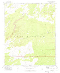
1971 Map of Tudecoz Spring
USGS Topo · Published 1975About this map
Tudecoz Spring and the Na Des Bah Well serve as critical water points in this arid stretch of the Navajo Indian Reservation during the early 1970s. The landscape is defined by the winding course of Wide Ruin Wash and the steep incisions of Pine Canyon, showing how topographic relief dictates the placement of infrastructure. Modern utility corridors are evident through a long Pipeline and an Aqueduct that cut across the high plateau. In the eastern portion of the map, industrial and logistical development is concentrated around a remote Landing Strip, supported by a Radio Tower and a Pumping Station. This survey, field-checked in 1971, captures the intersection of traditional land use and mid-century technical expansion in Apache County.
Find a feature on this map
16 named features on this map. Tap any name to fly to it.
Don’t see what you’re looking for? This feature index may not catch every label — zoom into the map to look around manually.
Map Details
Editions of this 1971 Tudecoz Spring Map
This is the sole edition of this map. No revisions or reprints were ever made.
Other maps of this area

1886 · Fort Defiance
USGS Topo · 1:250,000

1892 · Fort Defiance
USGS Topo · 1:250,000

1954 · Gallup
USGS Topo · 1:250,000

1955 · Zith-Tusayan Butte 3 NW
USGS Topo · 1:24,000

1955 · Zith-Tusayan Butte 3 NE
USGS Topo · 1:24,000

1958 · Gallup
USGS Topo · 1:250,000

1959 · Gallup
USGS Topo · 1:250,000

1962 · Gallup
USGS Topo · 1:250,000

1967 · Gallup
USGS Topo · 1:250,000

1971 · Wide Ruins
USGS Topo · 1:24,000