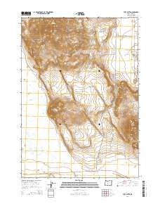
2014 Map of Tuff Butte
USGS Topo · Published 2014About this map
Tuff Butte and the Connley Hills dominate this high-desert landscape in northern Lake County, where volcanic landforms define the regional character. The topography is marked by distinctive elevations like Table Rock and Hayes Butte, separated by the passage at Arrow Gap. This area represents a transition from high ridges to the drainage basin of Silver Lake, fed by an intermittent network including Silver Cr, Bunyard Cr, and Murdock Cr. Human activity is primarily traced through the infrastructure of the Fremont Hwy and Christmas Valley Hwy, alongside water management features such as Parks Reservoir. The map reveals the stark isolation of these buttes and the expansive ranching or conservation tracts typical of the Oregon outback, where historical land surveys like t27s r15e partitioned the open range.
Find a feature on this map
27 named features on this map. Tap any name to fly to it.
Don’t see what you’re looking for? This feature index may not catch every label — zoom into the map to look around manually.
Map Details
Editions of this 2014 Tuff Butte Map
This is the sole edition of this map. No revisions or reprints were ever made.
Other maps of this area

1955 · Crescent
USGS Topo · 1:250,000

1957 · Crescent
USGS Topo · 1:250,000

1958 · Crescent
USGS Topo · 1:250,000

1968 · Silver Lake
USGS Topo · 1:24,000
1968 · Hager Mtn
USGS Topo · 1:24,000

1970 · Crescent
USGS Topo · 1:250,000

1979 · Crescent
USGS Topo · 1:100,000

1981 · Thorn Lake
USGS Topo · 1:24,000

1981 · Lane Lake
USGS Topo · 1:24,000
1981 · Tuff Butte
USGS Topo · 1:24,000