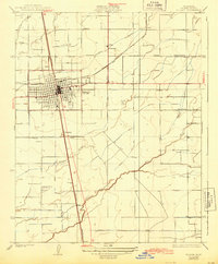
1927 Map of Tulare
USGS Topo · Published 1943About this map
Tulare serves as a major agricultural and transit hub in the San Joaquin Valley on this 1925 survey, showing the city's grid expanding toward the Atchison Topeka and and Southern Pacific rail lines. The surrounding landscape is defined by the complex water management systems of the era, including the Tulare Canal and natural drainage features like Elk Bayou and Bates Slough. The rural economy is visible through the positioning of the Oakland Colony School, Oakdale School, and Bliss School, which anchored scattered farming communities such as Swall, Elba, and Burling. This map captures the region's mid-1920s development, illustrating the transition from open wetlands and creeks to a highly organized network of canals and irrigation ditches that transformed Tulare County into a productive center. Features such as the Tulare Golf Links and various benchmarks offer valuable points of reference for those studying the early 20th-century footprint of this Central Valley community.
Find a feature on this map
20 named features on this map. Tap any name to fly to it.
Don’t see what you’re looking for? This feature index may not catch every label — zoom into the map to look around manually.
Map Details
Editions of this 1927 Tulare Map
3 editions found
Other maps of this area

1925 · Tulare
USGS Topo · 1:31,680

1925 · Tipton
USGS Topo · 1:31,680

1926 · Goshen
USGS Topo · 1:31,680

1926 · Exeter
USGS Topo · 1:31,680

1927 · Cairns Corner
USGS Topo · 1:31,680

1927 · Lake View School
USGS Topo · 1:31,680

1927 · Paige
USGS Topo · 1:31,680

1927 · Visalia
USGS Topo · 1:31,680

1927 · Tulare
USGS Topo · 1:31,680

1928 · Tipton
USGS Topo · 1:31,680