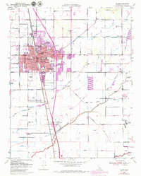
1950 Map of Tulare
USGS Topo · Published 1979About this map
The agricultural and transit hub of Tulare appears here during a period of post-war expansion, centered at the busy junction of the Southern Pacific and Atchison Topeka and Santa Fe railroads. The town's civic core is well-defined by landmark structures like City Hall, the Post Office, and the Tulare Cemetery. The surrounding landscape is dominated by a complex network of irrigation infrastructure, including the Tulare District Canal and Rockyford Ditch, which supported the region's productive orchards and fields. To the south, the Tulare Municipal Airport and Rankin Airfield reflect the era's growing aviation infrastructure, while rural life is anchored by institutions like the Oakland Colony School and the Old Peoples Home. The map captures the transition from a traditional rail-oriented town to a modernizing valley center defined by highway development and specialized facilities like the County Fairgrounds.
Find a feature on this map
67 named features on this map. Tap any name to fly to it.
Don’t see what you’re looking for? This feature index may not catch every label — zoom into the map to look around manually.
Map Details
Editions of this 1950 Tulare Map
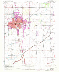
2 editions found
Other maps of this area

1925 · Tulare
USGS Topo · 1:31,680

1925 · Tipton
USGS Topo · 1:31,680

1926 · Goshen
USGS Topo · 1:31,680

1926 · Exeter
USGS Topo · 1:31,680

1927 · Cairns Corner
USGS Topo · 1:31,680

1927 · Lake View School
USGS Topo · 1:31,680

1927 · Paige
USGS Topo · 1:31,680

1927 · Visalia
USGS Topo · 1:31,680

1927 · Tulare
USGS Topo · 1:31,680

1928 · Tipton
USGS Topo · 1:31,680