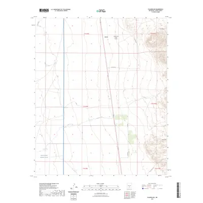
2023 Map of Tularosa NE
USGS Topo · Published 2023About this map
White Sands Missile Range occupies the southwestern corner of this desert landscape, where government restricted zones meet the varied terrain of Otero County. The settlement of Salinas is situated near the northern edge, nestled between the drainage of Salinas Draw and the more pronounced Coyote Canyon. Water is the defining resource of this arid region, marked by isolated points like Chase Spring, West Spring, and Lowen Spring, while the ephemeral Temporal Creek and Three Rivers navigate the wide plains. To the east, the topography rises sharply toward the heights of Sierra Blanca and the Coyote Hills, creating a stark vertical contrast to the surrounding flats. The grid of early land surveys is evident through township markers like t12s r9e, while remote tracks such as Snake Tank Rd and Co Rd B022 provide the primary access through this sparsely inhabited section of New Mexico.
Find a feature on this map
24 named features on this map. Tap any name to fly to it.
Don’t see what you’re looking for? This feature index may not catch every label — zoom into the map to look around manually.
Map Details
Editions of this 2023 Tularosa NE Map
This is the sole edition of this map. No revisions or reprints were ever made.
Other maps of this area

1916 · Tularosa
USGS Topo · 1:125,000

1947 · Three Rivers
USGS Topo · 1:62,500

1948 · Tularosa
USGS Topo · 1:62,500

1950 · Three Rivers
USGS Topo · 1:24,000

1950 · Sierra Blanca Peak
USGS Topo · 1:62,500

1950 · Mescalero
USGS Topo · 1:62,500

1954 · Tularosa
USGS Topo · 1:250,000

1955 · Roswell
USGS Topo · 1:250,000

1958 · Roswell
USGS Topo · 1:250,000

1958 · Tularosa
USGS Topo · 1:250,000