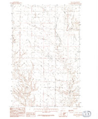
1984 Map of Tule Lake
USGS Topo · Published 1992About this map
Tule Lake and its surrounding drainage basin characterize this portion of Blaine County during the mid-1980s. The landscape is defined by the winding paths of Fifteenmile Creek and Coal Creek, which cut through the high plains terrain. This 1984 field-checked survey illustrates a largely open ranching environment, marked by isolated livestock infrastructure such as a Corral and various unimproved trails that connect remote sections of the township. The presence of Threemile Creek in the northeast corner further emphasizes the importance of these seasonal waterways in an arid region where water management and topography dictated the patterns of land use and movement. For those studying the rural development of north-central Montana, the map offers a precise look at the transition between rolling uplands and the creek beds that serve as primary landmarks in this expanse.
Find a feature on this map
5 named features on this map. Tap any name to fly to it.
Don’t see what you’re looking for? This feature index may not catch every label — zoom into the map to look around manually.
Map Details
Editions of this 1984 Tule Lake Map
2 editions found
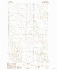
Other maps of this area

1904 · Chinook
USGS Topo · 1:62,500

1905 · Harlem
USGS Topo · 1:62,500

1912 · Zurich
USGS Topo · 1:125,000

1913 · Cherry Ridge
USGS Topo · 1:125,000

1953 · Havre
USGS Topo · 1:250,000

1957 · Havre
USGS Topo · 1:250,000

1958 · Havre
USGS Topo · 1:250,000

1964 · Rabbit Hills
USGS Topo · 1:24,000
1964 · Fort Belknap Siding
USGS Topo · 1:24,000
1964 · Chinook
USGS Topo · 1:24,000