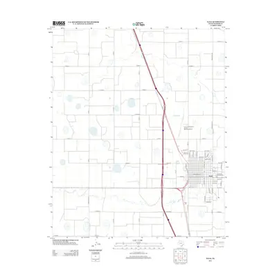
2012 Map of Tulia
USGS Topo · Published 2012About this map
Tulia serves as the focal point of this Swisher County landscape, showing a structured grid of streets including W Broadway Ave and Railroad Ave. The town is the center of a vast agricultural and transport network on the Llano Estacado, where the local economy is closely tied to the highway and rail corridors that intersect here. On the northern outskirts, the City of Tulia/Swisher County Municipal Airport provides an essential link for the region, while the Rose Cem sits to the south along the edge of the residential expansion. Outside the town limits, the land is organized into a precise rectilinear grid of county roads, such as Co Road J and Co Road L, reflecting the systematic division of the High Plains for industrial-scale farming and ranching. Small depressions and playa lakes are scattered throughout the surrounding sections, marking the natural hydrology of this flat terrain.
Find a feature on this map
56 named features on this map. Tap any name to fly to it.
Don’t see what you’re looking for? This feature index may not catch every label — zoom into the map to look around manually.
Map Details
Editions of this 2012 Tulia Map
This is the sole edition of this map. No revisions or reprints were ever made.
Other maps of this area

1954 · Plainview
USGS Topo · 1:250,000

1958 · Plainview
USGS Topo · 1:250,000

1965 · Edmonson NE
USGS Topo · 1:24,000

1965 · Tulia
USGS Topo · 1:24,000

1965 · Lakeview
USGS Topo · 1:24,000

1965 · Happy
USGS Topo · 1:24,000

1965 · Center Plains School
USGS Topo · 1:24,000

1966 · Tulia NW
USGS Topo · 1:24,000

1968 · Tule Lake
USGS Topo · 1:24,000

1969 · Tule Lake NW
USGS Topo · 1:24,000