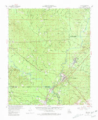
1954 Map of Tullos
USGS Topo · Published 1981About this map
The lumber and rail corridors of Central Louisiana define this 1950s landscape, where the Missouri Pacific and Louisiana and Arkansas railroads intersect at Tullos. This era shows a region shaped by industrial transport, with the Urania Lumber Co railroad lines branching deep into the timberlands. The southern portion of the map is dominated by the Kisatchie National Forest, intersected by the Little River. Local genealogy is well-represented through numerous family-named landmarks and rural congregations, such as Old Shady Grove Ch and Zion Hill Ch. Many small cemeteries like James Cem and Nelson Cem are plotted alongside creeks such as Beech Creek and Castor Creek, providing a detailed view of the settlement patterns across the Winn Parish, Caldwell Parish, La Salle Parish, and Grant Parish boundaries during a period of active rail operations.
Find a feature on this map
95 named features on this map. Tap any name to fly to it.
Don’t see what you’re looking for? This feature index may not catch every label — zoom into the map to look around manually.
Map Details
Editions of this 1954 Tullos Map
4 editions found

Other maps of this area

1932 · Colfax NE
USGS Topo · 1:31,680

1936 · Colfax
USGS Topo · 1:62,500

1936 · Pollock
USGS Topo · 1:62,500

1940 · Columbia
USGS Topo · 1:62,500

1941 · Jena
USGS Topo · 1:62,500

1941 · Pollock
USGS Topo · 1:62,500

1949 · Jonesboro
USGS Topo · 1:62,500

1950 · Jonesboro
USGS Topo · 1:62,500

1950 · Winnfield
USGS Topo · 1:62,500

1951 · Winnfield
USGS Topo · 1:62,500