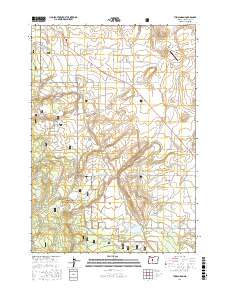
2017 Map of Tumalo Dam
USGS Topo · Published 2017About this map
Tumalo Dam and the Upper Tumalo Reservoir anchor this 2017 survey of the Deschutes County landscape, where the management of water is the primary architect of the terrain. The complex irrigation network of the High Desert is visible in the paths of the Maxwell Ditch, Plainview Ditch, and the Columbia Southern Canal. These engineered waterways contrast with natural features like Dry Canyon and the broad expanse of Bull Flat. The western edge of the map transitions into the Deschutes National Forest, while the northern section shows the development of residential areas and the Sage Ranch Airport. The map documents a modern era of land use where historic agricultural needs and suburban growth meet at the foot of the Cascades, evidenced by the numerous named roads like Harrington Loop Rd and Cloverdale Rd that grid the open plains.
Find a feature on this map
67 named features on this map. Tap any name to fly to it.
Don’t see what you’re looking for? This feature index may not catch every label — zoom into the map to look around manually.
Map Details
Editions of this 2017 Tumalo Dam Map
This is the sole edition of this map. No revisions or reprints were ever made.
Other maps of this area

1926 · Bend
USGS Topo · 1:125,000

1929 · Bend
USGS Topo · 1:125,000

1929 · Three Sisters
USGS Topo · 1:125,000

1932 · Three Sisters
USGS Topo · 1:125,000

1955 · Bend
USGS Topo · 1:250,000

1957 · Bend
USGS Topo · 1:250,000

1958 · Bend
USGS Topo · 1:250,000

1959 · Broken Top
USGS Topo · 1:62,500

1959 · Sisters
USGS Topo · 1:62,500
1962 · Bend
USGS Topo · 1:24,000