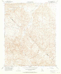
1956 Map of Tumey Hills
USGS Topo · Published 1964About this map
The high ridges of the Panoche Hills and Tumey Hills dominate this mid-century survey of the arid interior borderland between Fresno and San Benito counties. The landscape is defined by deep drainage networks such as Panoche Creek, Silver Creek, and Tumey Gulch, which cut through the uplifted terrain. An Approximate Boundary line runs diagonally across the topography, marking the transition between the two counties near the Griswold Hills. Evidence of resource exploration is present in the form of several scattered Oil Wells, a solitary Oil Well, and a Prospect located in the northern reaches near a Gaging Station. The infrastructure is sparse, consisting primarily of remote Jeep Trails and a Reservoir, reflecting the region's rugged isolation and focus on watershed and mineral management.
Find a feature on this map
16 named features on this map. Tap any name to fly to it.
Don’t see what you’re looking for? This feature index may not catch every label — zoom into the map to look around manually.
Map Details
Editions of this 1956 Tumey Hills Map
4 editions found
Other maps of this area

1913 · Panoche
USGS Topo · 1:125,000

1915 · Priest Valley
USGS Topo · 1:125,000

1921 · Tierra Loma School
USGS Topo · 1:31,680

1922 · Chaney Ranch
USGS Topo · 1:31,680

1923 · Tierra Loma School
USGS Topo · 1:31,680

1923 · Monocline Ridge
USGS Topo · 1:31,680

1943 · New Idria
USGS Topo · 1:62,500

1943 · Hernandez Valley
USGS Topo · 1:62,500

1944 · Hernandez Valley
USGS Topo · 1:62,500

1944 · Panoche Valley
USGS Topo · 1:62,500