1956 Map of Tumey Hills
USGS Topo · Published 1972About this map
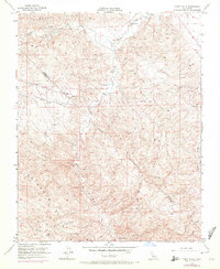
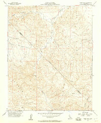
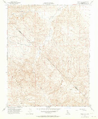
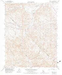
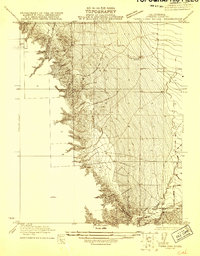
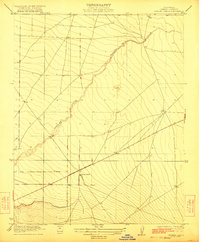
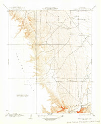
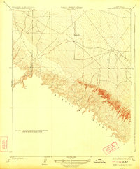
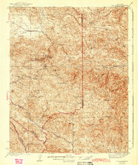
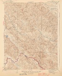
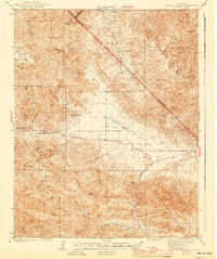
Vallecitos Oil Field and the complex drainage systems of the California interior dominate this 1956 landscape, which was later updated with 1971 aerial data. The map reveals the industrial footprint of resource extraction in the high-relief terrain where the Fresno and San Benito County line traverses the Tumey Hills. Water management and energy infrastructure are visible through the inclusion of a Gaging Station on Panoche Creek and a major Pipeline cutting through the northern hills. The terrain is characterized by a network of seasonal watercourses, including Silver Creek, Tumey Gulch, and Ciervo Gulch, which carve through the Panoche Hills and Griswold Hills. This survey documents a transitional era in California's high-desert topography, showing the early expansion of oil fields and the utilitarian infrastructure required to support remote operations.
Find a feature on this map
13 named features on this map. Tap any name to fly to it.
Don’t see what you’re looking for? This feature index may not catch every label — zoom into the map to look around manually.
Map Details
Editions of this 1956 Tumey Hills Map
4 editions found
Other maps of this area

1913 · Panoche
USGS Topo · 1:125,000

1915 · Priest Valley
USGS Topo · 1:125,000
1921 · Tierra Loma School
USGS Topo · 1:31,680
1922 · Chaney Ranch
USGS Topo · 1:31,680
1923 · Tierra Loma School
USGS Topo · 1:31,680
1923 · Monocline Ridge
USGS Topo · 1:31,680
1943 · New Idria
USGS Topo · 1:62,500

1943 · Hernandez Valley
USGS Topo · 1:62,500
1944 · Hernandez Valley
USGS Topo · 1:62,500
1944 · Panoche Valley
USGS Topo · 1:62,500