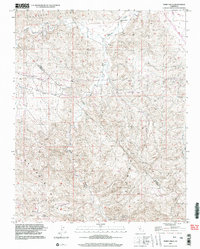
2000 Map of Tumey Hills
USGS Topo · Published 2002About this map
The Vallecitos Oil Field and surrounding terrain at the boundary of Fresno and San Benito counties are meticulously documented in this late-twentieth-century study. This arid landscape is defined by the heavy presence of resource extraction, with numerous Oil Wells and Prospects scattered across the high ground of the Panoche Hills and Tumey Hills. The drainage network, including Panoche Creek and Silver Creek, cuts deep through the topography, with a Gaging Station monitoring the flow in the northern sector. High points like VABM Griswold provide survey control for this sparsely populated region where industrial activity and complex landforms meet. The map reveals the intricate system of unimproved roads and pipelines necessary to service the local energy infrastructure within these California ranges.
Find a feature on this map
15 named features on this map. Tap any name to fly to it.
Don’t see what you’re looking for? This feature index may not catch every label — zoom into the map to look around manually.
Map Details
Editions of this 2000 Tumey Hills Map
2 editions found
Other maps of this area

1913 · Panoche
USGS Topo · 1:125,000

1915 · Priest Valley
USGS Topo · 1:125,000

1921 · Tierra Loma School
USGS Topo · 1:31,680

1922 · Chaney Ranch
USGS Topo · 1:31,680

1923 · Tierra Loma School
USGS Topo · 1:31,680

1923 · Monocline Ridge
USGS Topo · 1:31,680

1943 · New Idria
USGS Topo · 1:62,500

1943 · Hernandez Valley
USGS Topo · 1:62,500

1944 · Hernandez Valley
USGS Topo · 1:62,500

1944 · Panoche Valley
USGS Topo · 1:62,500