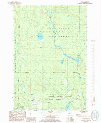
1985 Map of Tunis
USGS Topo · Published 1986About this map
Copper Country State Forest dominates this Northwoods landscape, straddling the boundary of Baraga and Iron counties in the mid-1980s. The region is defined by an intricate network of waterways, most notably the Net River and its various tributaries. The Net River Flooding area indicates a low-lying, swampy terrain where water management or natural beaver activity has altered the river's course. Small settlements like Tunis and Park Siding appear as quiet outposts along the forest edge, likely tied to the timber industry or local rail history.
Find a feature on this map
19 named features on this map. Tap any name to fly to it.
Don’t see what you’re looking for? This feature index may not catch every label — zoom into the map to look around manually.
Map Details
Editions of this 1985 Tunis Map
This is the sole edition of this map. No revisions or reprints were ever made.
Other maps of this area

1895 · Ned Lake
USGS Topo · 1:62,500

1895 · Perch Lake
USGS Topo · 1:62,500

1954 · Perch Lake
USGS Topo · 1:62,500

1954 · Sidnaw
USGS Topo · 1:62,500

1955 · Ned Lake
USGS Topo · 1:62,500

1955 · Herman
USGS Topo · 1:62,500

1958 · Iron River
USGS Topo · 1:250,000

1960 · Iron River
USGS Topo · 1:250,000

1961 · Iron River
USGS Topo · 1:250,000

1967 · Iron River
USGS Topo · 1:250,000