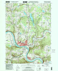
2000 Map of Tunkhannock
USGS Topo · Published 2001About this map
Tunkhannock serves as the focal point of this Wyoming County landscape, situated at the prominent bend where Tunkhannock Creek meets the Susquehanna River. The map illustrates a community anchored by its river valley geography, with the Roosevelt Highway and Lehigh Valley rail lines following the water’s edge. Local infrastructure is well-defined, ranging from the Skyhaven Airport to the Athletic Fields and Golf Course that serve the borough's residents.
Find a feature on this map
70 named features on this map. Tap any name to fly to it.
Don’t see what you’re looking for? This feature index may not catch every label — zoom into the map to look around manually.
Map Details
Editions of this 2000 Tunkhannock Map
This is the sole edition of this map. No revisions or reprints were ever made.
Other maps of this area

1891 · Harveys Lake
USGS Topo · 1:62,500

1893 · Harvey Lake
USGS Topo · 1:62,500

1893 · Pittston
USGS Topo · 1:62,500

1943 · Scranton
USGS Topo · 1:125,000

1945 · Meshoppen
USGS Topo · 1:62,500

1945 · Auburn Center
USGS Topo · 1:24,000

1945 · Meshoppen
USGS Topo · 1:24,000

1946 · Tunkhannock
USGS Topo · 1:62,500

1946 · Noxen
USGS Topo · 1:24,000

1946 · Ransom
USGS Topo · 1:24,000
Featured Places
- Falls Township, PA
- Tunkhannock, PA
- Lemon Township, PA
- Brookside, Tunkhannock Township
- Marcy, Tunkhannock Township