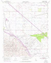
1954 Map of Tupman
USGS Topo · Published 1976About this map
The Elk Hills dominate the southwestern terrain of this Kern County survey, serving as the backdrop for the massive Naval Petroleum Reserve No 1. The landscape is a complex intersection of natural drainage and industrial water management, where the Kern River Channel and Bypass meet a dense network of infrastructure including the Main Levee Canal and the California Aqueduct. This era of development is defined by the extraction economy, with the North Coles Levee Oil Field and South Coles Levee Oil Field blanketing the valley floor with wells, pipelines, and sumps.
Find a feature on this map
30 named features on this map. Tap any name to fly to it.
Don’t see what you’re looking for? This feature index may not catch every label — zoom into the map to look around manually.
Map Details
Editions of this 1954 Tupman Map
3 editions found
Other maps of this area

1910 · Buena Vista Lake
USGS Topo · 1:125,000

1912 · Buena Vista Lake
USGS Topo · 1:125,000

1929 · Stevens
USGS Topo · 1:31,680

1929 · Coles Levee
USGS Topo · 1:31,680

1929 · Mouth of Kern
USGS Topo · 1:31,680

1930 · Millux
USGS Topo · 1:31,680

1930 · Rosedale
USGS Topo · 1:31,680

1931 · Rio Bravo
USGS Topo · 1:31,680

1932 · East Elk Hills
USGS Topo · 1:31,680

1932 · Mouth of Kern
USGS Topo · 1:31,680