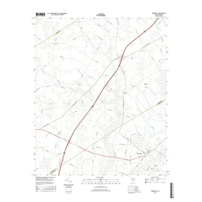
2017 Map of Turbeville
USGS Topo · Published 2017About this map
Turbeville serves as the primary hub in this lowcountry landscape, where the coastal plain is defined by an intricate network of wetlands and drainage basins. The area is characterized by massive swamp systems, including the expansive Pudding Swamp and Hope Swamp, which dictate the placement of local roads and settlements. Smaller water features like Cowboy Swamp and Dial Bay further illustrate the hydrologic character of the South Carolina interior. Historically significant sites such as Asbury Cem and Shiloh Cem are situated near the community of Shiloh, offering valuable points of reference for genealogists. The map also records the rural infrastructure of the early 21st century, with local names like Woods Millpond and various branches such as Threemile Br and Newman Br marking the terrain at the intersection of Lee, Sumter, and Clarendon counties.
Find a feature on this map
85 named features on this map. Tap any name to fly to it.
Don’t see what you’re looking for? This feature index may not catch every label — zoom into the map to look around manually.
Map Details
Editions of this 2017 Turbeville Map
This is the sole edition of this map. No revisions or reprints were ever made.
Other maps of this area

1920 · Mayesville
USGS Topo · 1:48,000

1921 · Mayesville
USGS Topo · 1:62,500

1940 · Florence West
USGS Topo · 1:62,500

1941 · Spartanburg
USGS Topo · 1:250,000

1943 · Mayesville
USGS Topo · 1:62,500

1945 · Florence West
USGS Topo · 1:62,500

1946 · Lake City
USGS Topo · 1:62,500

1949 · Georgetown
USGS Topo · 1:250,000

1953 · Florence
USGS Topo · 1:250,000

1953 · Spartanburg
USGS Topo · 1:250,000