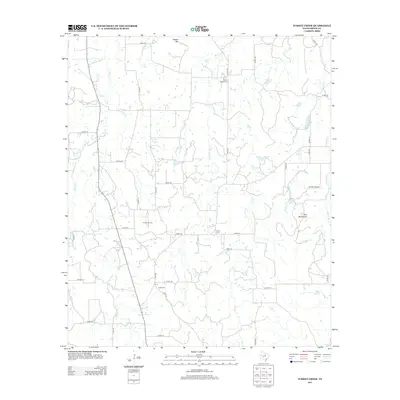
2012 Map of Turkey Creek
USGS Topo · Published 2012About this map
The X-Ray Gas Field and several scattered cemeteries define this portion of the Texas landscape in the early twenty-first century. This territory is characterized by a dense network of county roads, such as Co RD-126 and Co RD-116, which support the region's energy extraction and rural residential patterns. For those researching local families, the presence of X-Ray Cem, Liberty Cem, and Russel Chapel Cem offers specific geographic points of interest near historically named heights like Deaton Mtn. Waterways including Turkey Cr and Big Sunday Cr drain the terrain toward the south and east, while the Kimzey Airport serves as a small aviation landmark among the ridges of the Twin Mountains. The infrastructure reveals a transition between agricultural land use and industrial resource development.
Find a feature on this map
42 named features on this map. Tap any name to fly to it.
Don’t see what you’re looking for? This feature index may not catch every label — zoom into the map to look around manually.
Map Details
Editions of this 2012 Turkey Creek Map
This is the sole edition of this map. No revisions or reprints were ever made.
Other maps of this area

1890 · Stephenville
USGS Topo · 1:125,000

1891 · Palo Pinto
USGS Topo · 1:125,000

1918 · Palo Pinto
USGS Topo · 1:125,000

1920 · Stephenville
USGS Topo · 1:125,000

1931 · Santo
USGS Topo · 1:62,500

1954 · Abilene
USGS Topo · 1:250,000

1958 · Abilene
USGS Topo · 1:250,000
1959 · Lipan
USGS Topo · 1:62,500

1959 · Gordon
USGS Topo · 1:62,500

1961 · Knob Hill
USGS Topo · 1:24,000