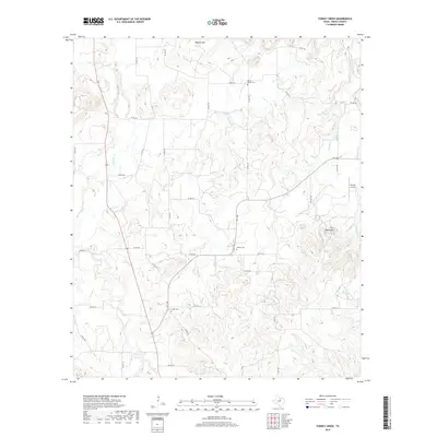
2019 Map of Turkey Creek
USGS Topo · Published 2019About this map
X-Ray Cem and Liberty Cem anchor the rural landscape of north-central Erath County in this 2019 survey. The terrain is defined by a dense network of seasonal drainages, including Barton Cr and Lost Cr, which carve through the limestone-streaked uplands toward Stewart Lake. This modern record reveals a land-use pattern where traditional family burial grounds and small-scale cattle ranching coexist with specialized infrastructure like the Kimzey Airport. Prominent topographic features such as Twin Mountains and Deaton Mtn serve as permanent landmarks amidst a grid of county roads that have long facilitated movement between these isolated hills. The persistence of names like Russel Chapel Cem provides a direct link to the area's 19th-century settlement history, even as the landscape transitions into the contemporary era.
Find a feature on this map
43 named features on this map. Tap any name to fly to it.
Don’t see what you’re looking for? This feature index may not catch every label — zoom into the map to look around manually.
Map Details
Editions of this 2019 Turkey Creek Map
This is the sole edition of this map. No revisions or reprints were ever made.
Other maps of this area

1890 · Stephenville
USGS Topo · 1:125,000

1891 · Palo Pinto
USGS Topo · 1:125,000

1918 · Palo Pinto
USGS Topo · 1:125,000

1920 · Stephenville
USGS Topo · 1:125,000

1931 · Santo
USGS Topo · 1:62,500

1954 · Abilene
USGS Topo · 1:250,000

1958 · Abilene
USGS Topo · 1:250,000
1959 · Lipan
USGS Topo · 1:62,500

1959 · Gordon
USGS Topo · 1:62,500

1961 · Knob Hill
USGS Topo · 1:24,000