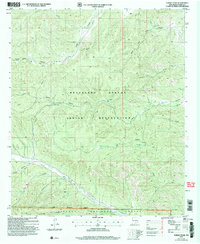
2004 Map of Turkey Peak
USGS Topo · Published 2006About this map
The Mescalero Apache Indian Reservation and the northern edge of the Lincoln National Forest meet in this 2004 land management study. The landscape is dominated by a complex network of canyons and elevated flats, most notably the high point of Turkey Peak and the nearby Tommy Jones Flat. Water management in this arid environment is evidenced by the numerous named tanks and wells scattered throughout the canyons, such as North Indian Tank, Upper Indian Tank, and Turkey Well.
Find a feature on this map
31 named features on this map. Tap any name to fly to it.
Don’t see what you’re looking for? This feature index may not catch every label — zoom into the map to look around manually.
Map Details
Editions of this 2004 Turkey Peak Map
This is the sole edition of this map. No revisions or reprints were ever made.
Other maps of this area

1952 · Cloudcroft
USGS Topo · 1:62,500

1954 · Carlsbad
USGS Topo · 1:250,000

1955 · Roswell
USGS Topo · 1:250,000

1958 · Carlsbad
USGS Topo · 1:250,000

1958 · Roswell
USGS Topo · 1:250,000

1962 · Roswell
USGS Topo · 1:250,000

1963 · Clements Ranch
USGS Topo · 1:24,000

1963 · Mayhill
USGS Topo · 1:24,000

1963 · Turkey Peak
USGS Topo · 1:24,000

1963 · Deadman Lake
USGS Topo · 1:24,000