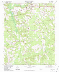
1984 Map of Turkey
USGS Topo · Published 1984About this map
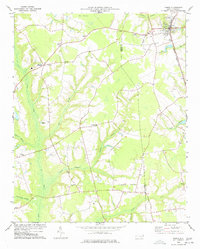
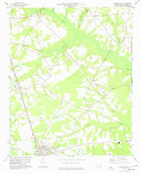
Turkey stands as a central hub on this coastal plain landscape, where the Seaboard railroad tracks intersect with established crossroads. The terrain is deeply defined by the winding course of Six Runs Creek and its many tributaries, including Rowan Branch and Turkey Creek. These waterways and their associated swamplands historically dictated the placement of settlements and transport routes, creating a network of small, rural communities connected by light-duty roads. Genealogists will find a wealth of local landmarks, from the clusters of unnamed Cem plots to named gathering places like St Stephens Ch and Wilson Chapel. The border between Sampson and Duplin counties runs through the eastern portion of the map, illustrating how natural drainage features like Carltons Branch and Stewarts Creek serve as local landmarks in this agricultural region during the early 1980s.
Find a feature on this map
28 named features on this map. Tap any name to fly to it.
Don’t see what you’re looking for? This feature index may not catch every label — zoom into the map to look around manually.
Map Details
Editions of this 1984 Turkey Map
This is the sole edition of this map. No revisions or reprints were ever made.
Other maps of this area
1909 · Coharie
USGS Topo · 1:62,500

1953 · Florence
USGS Topo · 1:250,000

1953 · Raleigh
USGS Topo · 1:250,000

1954 · Florence
USGS Topo · 1:250,000

1954 · Raleigh
USGS Topo · 1:250,000
1959 · Garland
USGS Topo · 1:62,500
1962 · Rose Hill
USGS Topo · 1:62,500
1975 · Faison
USGS Topo · 1:24,000
1977 · Warsaw North
USGS Topo · 1:24,000

1982 · Elizabethtown
USGS Topo · 1:100,000