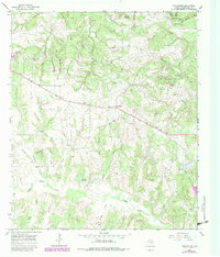
1965 Map of Turlington
USGS Topo · Published 1983About this map
Turlington serves as the central point of this Freestone County landscape, captured during a period of active natural resource extraction and rural community life. The terrain is defined by a dense network of waterways including Big Brown Creek and Upper Keechi Creek, which wind through a landscape dotted with signs of the Texas energy sector. Numerous Gas Wells and an extensive pipeline network traverse the area, illustrating the industrial footprint on the land during the mid-1960s and early 1980s. Evidence of local genealogy and community heritage is found in the scattered sites of Mt Zion Cem and Day Cem, while religious and social life is anchored by Antioch Ch and Mt Zion Park. The presence of several Gravel Pits and geographic landmarks like Pilot Knob further characterize this region's blend of agriculture and industry.
Find a feature on this map
37 named features on this map. Tap any name to fly to it.
Don’t see what you’re looking for? This feature index may not catch every label — zoom into the map to look around manually.
Map Details
Editions of this 1965 Turlington Map
2 editions found
Other maps of this area

1919 · Fairfield
USGS Topo · 1:62,500

1949 · Tennessee Colony
USGS Topo · 1:62,500

1950 · Tennessee Colony
USGS Topo · 1:62,500

1953 · Palestine
USGS Topo · 1:250,000

1954 · Waco
USGS Topo · 1:250,000

1955 · Waco
USGS Topo · 1:250,000

1957 · Palestine
USGS Topo · 1:250,000

1961 · Young
USGS Topo · 1:24,000
1963 · Stewards Mill
USGS Topo · 1:24,000

1964 · Keechi
USGS Topo · 1:24,000