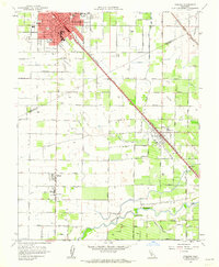
1961 Map of Turlock
USGS Topo · Published 1962About this map
Turlock serves as the focal point of this Central Valley survey, showcasing a well-established urban grid during the early 1960s. The landscape is defined by the intersection of the Southern Pacific and Tidewater Southern railroads, which facilitated the region's agricultural economy. This commercial hub is surrounded by smaller farming communities like Delhi, Hilmar, and Irwin, each anchored by local institutions such as Elim Sch and Sacred Heart Sch.
Find a feature on this map
51 named features on this map. Tap any name to fly to it.
Don’t see what you’re looking for? This feature index may not catch every label — zoom into the map to look around manually.
Map Details
Editions of this 1961 Turlock Map
3 editions found
Other maps of this area

1916 · Mitchell School
USGS Topo · 1:31,680

1916 · Cressey
USGS Topo · 1:31,680

1916 · Montpellier
USGS Topo · 1:31,680

1916 · Denair
USGS Topo · 1:31,680

1916 · Ceres
USGS Topo · 1:31,680

1917 · Turlock
USGS Topo · 1:31,680

1918 · Arena
USGS Topo · 1:31,680

1918 · Stevinson
USGS Topo · 1:31,680

1918 · Gustine
USGS Topo · 1:31,680

1939 · Modesto East
USGS Topo · 1:62,500