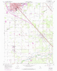
1961 Map of Turlock
USGS Topo · Published 1978About this map
Agricultural development defines the Central Valley landscape between Turlock and the Merced River in this early 1960s study. The city of Turlock serves as the primary urban hub, centered around the intersection of the Southern Pacific railroad and major thoroughfares. Local infrastructure is highly visible, featuring community anchors like Sacred Heart Hosp, Turlock High Sch, and the Turlock Country Club. To the south, the smaller settlements of Delhi, Hilmar, and Irwin are connected by a dense grid of farm-to-market roads and an extensive irrigation network, including the Turlock Lake Aqueduct, Highline Canal, and several laterals such as Lateral No 4. This network highlights the region's reliance on managed water systems to support its expanding orchard and field operations. Transportation is further bolstered by the Tidewater Southern and Atchison Topeka and Santa Fe rail lines, which provided vital links for the local economy during this era of growth.
Find a feature on this map
90 named features on this map. Tap any name to fly to it.
Don’t see what you’re looking for? This feature index may not catch every label — zoom into the map to look around manually.
Map Details
Editions of this 1961 Turlock Map
3 editions found
Other maps of this area

1916 · Mitchell School
USGS Topo · 1:31,680

1916 · Cressey
USGS Topo · 1:31,680

1916 · Montpellier
USGS Topo · 1:31,680

1916 · Denair
USGS Topo · 1:31,680

1916 · Ceres
USGS Topo · 1:31,680

1917 · Turlock
USGS Topo · 1:31,680

1918 · Arena
USGS Topo · 1:31,680

1918 · Stevinson
USGS Topo · 1:31,680

1918 · Gustine
USGS Topo · 1:31,680

1939 · Modesto East
USGS Topo · 1:62,500